
THE DOON DOON DRIVE
A day to experience the Tweed's upper catchment waterways, remnant volcanic plugs and serene picnic areas
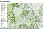
Map can be ENLARGED or re-positioned (PAN) with your device
Also, top left icon opens the Photo-trails menu then 'click' onto the pink diamonds AND top right icon opens Google Maps enlargement
Also, top left icon opens the Photo-trails menu then 'click' onto the pink diamonds AND top right icon opens Google Maps enlargement
|
|
Also, see Fran Hardy's account of her Doon Doon/ Mt Doughboy experiences in the Explore/Stories page |
Place Name Derivations*
|
DOON DOON
NIGHTCAP RANGE MOUNT MATHESON MOUNT DOUGHBOY CLARRIE HALL DAM CRAMS FARM MOUNT JERUSALEM MOUNT BURREL (Officially spelt with one 'l') MOUNT NARDI |
May be derived from an Aboriginal word 'tooun' meaning 'a grave'. Doon Doon Creek rises in the steep slopes of the Nightcap Range and flows generally north.
From 'night camp', after those who travelled or surveyed the range between the Tweed and Richmond River catchments. Postmen delivered the mail along the Nightcap Track to avoid the lowlands in times of flood. The peak is 804 metres high and named after the Government Surveyor George Matheson who, along with his assistant Arthur Gracie, surveyed the track over the Nightcap Range in the early 1870's. From the 'doughboy', a sizeable chunk of scone mixture or dumpling dough, set up in a bowl of stew. It rises 400 metres above the surrounding rich pasture country. Named after the prominent, and long serving Tweed Shire President (served 5 terms, between 1958 and 1979), the storage dam was opened in 1983. The waters of Doon Doon Creek flow into it. After James Cram who, along with his family, purchased a size-able property from the original selector in 1918. Primarily a dairy farm, they also operated a saw mill, a Clydesdale stud and telephone exchange. Perhaps after the ancient Walls of Jerusalem in the Middle East. In 1981 they were added to the UNESCO World Heritage site list. Originally built to protect the city, they are now a tourist attraction. The peak (933 metres) is also called Blue Knob. Possibly from the Aboriginal 'burrul' meaning 'wallaby' it stands at the western end of the Nightcap Range. The Blue Knob Range continues to the south. After Terania Shire Councillor Angelo Nardi who served from 1956 to 1961. * Source: Place Names of the Tweed and Brunswick Regions - Richmond Tweed Regional Library 1984 |
Header Image: Crams Farm Reserve, Clarrie Hall Dam waterway with distant Wollumbin Mt Warning - AR Photography