
OXLEY & ROUS RIVER CIRCUIT
Half-day drive exploring the Oxley and Rous River catchments and their headwater escarpments
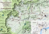
Half-day drive exploring the Oxley and Rous River catchments and their headwater escarpments
Map can be ENLARGED or re-positioned (PAN) with your device
Also, top left icon opens the Photo-trails menu then 'click' onto the brown diamonds AND top right icon opens Google Maps enlargement
Also, top left icon opens the Photo-trails menu then 'click' onto the brown diamonds AND top right icon opens Google Maps enlargement
Place Name Derivations *
|
OXLEY RIVER
ROUS RIVER CHILLINGHAM LIMPINWOOD CRYSTAL CREEK COUGALS BALD MOUNTAIN |
After Lieut. John Oxley who explored this waterway in 1823. This river has long been known to locals as the 'Middle Arm' of the Tweed River catchments.
After Captain Henry John Rous who also explored the Tweed River (South Arm) and Richmond Rivers in 1828. The Rous River was referred to as the North Arm by locals. Some diversity to this name: Originally called 'Bean Tree Crossing' (after the Black Bean tree Castanospermum australe), early settlers possibly renamed it after the Chillingham village in Northumberland County, England near their Tweed River. Also possibly from 'chinningum', an aboriginal word for the locality. Richard Wood, an early cedar-getter and selector sustained a leg injury whilst crossing a creek which subsequently became known as Hopping Dick Ck. His permanent limp caused locals to name the locality as Limpinwood. Named because of the clear waters with many small tributaries rising in the Numinbah Nature Reserve. Said to be a sacred Aboriginal word 'koggel' meaning big rock. Also possibly from the Gidabal 'guhgur' for the Rose Apple tree. The west peak is 732 m high with the east peak at 694 m. With rhyolite capping, thin soils and mostly grassy vegetation, this 628m mountain once stood bare in contrast to the surrounding forests of the escarpments. In recent times, woody weeds including Camphor laurel have taken hold. * Source: Place Names of the Tweed and Brunswick Regions - Richmond Tweed Regional Library 1984 |
Header Image: Distant western caldera escarpment (incl, The Pinnacle) and rolling hills west of Tyalgum, from Boxsell Road - AR photography