
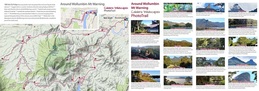
AROUND WOLLUMBIN MT WARNING
A full day drive around the mountain with sixteen 'top spots' to appreciate the sights and sounds of the caldera.
NOTE: Wollumbin National Park (and the summit track) is closed until further notice
A full day drive around the mountain with sixteen 'top spots' to appreciate the sights and sounds of the caldera.
NOTE: Wollumbin National Park (and the summit track) is closed until further notice
Map can be ENLARGED or re-positioned (PAN) with your device
Also, top left icon opens the Photo-trails menu then 'click' onto the red diamonds AND top right icon opens Google Maps enlargement
Also, top left icon opens the Photo-trails menu then 'click' onto the red diamonds AND top right icon opens Google Maps enlargement
Place Name Derivations *
|
BUDD PARK
EUNGELLA TYALGUM BRAYS CREEK MEBBIN BYRRILL CREEK PUMPENBIL THE PINNACLE |
Named after a prominent Murwillumbah family. It was the site of the North Coast Steam Navigation Company, store houses and wharves. In 1967, all properties were acquired for the construction of the new bridge. Apex and Lions Clubs jointly created parklands.
Said to be an Aboriginal word meaning 'mountain of the mists'. Also the name of a property owned by Mr Isaacs, the first manager of the Condong Sugar Mill in 1880. Said to be derived from Aboriginal words: daldal (a shrub) and gum (a place). Also may mean 'a place of tall timbers. Part of a large cattle grazing lease held by early pioneer Joshua Bray in the 1860's, along with brother-in-law Samuel Gray. Both were involved with several properties in the Tweed, clearing the land of timber and cutting tracks to establish transport links. From the Bundjalung mibin, meaning ‘hawk’. It was formerly an intensively logged hardwood state forest (mostly ironbark, tallowwood and Hoop Pine), declared a National Park in 1999. Has two small World Heritage areas (Mebbin Lagoon and Forty Spur Flora Reserves). Probably from burrul, an Aboriginal word meaning 'wallaby'. Aboriginal word said to refer to a certain tree (species unknown). Joshua Bray knew it as Coowarragum ('warragum' meaning 'windy place') up until the 1860's where Aboriginal ceremonies were held on a river flat. A descriptive name for this famous landmark consisting of a narrow knife-edge of rhyolite rock jutting out from the escarpment at an elevation of 919 metres. The top is only 5 metres wide. * Source: Place Names of the Tweed and Brunswick Regions - Richmond Tweed Regional Library 1984 |
Header image: Mt Warning summit (north west face, from Tyalgum village - AR photography