
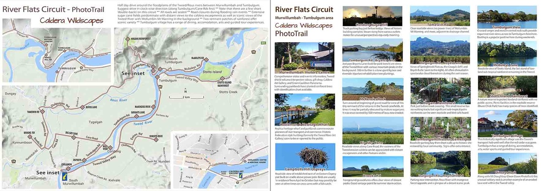
RIVER FLATS CIRCUIT
Half day drive through the Tweed & Rous river floodplain and surrounds between Murwillumbah and Tumbulgum
Half day drive through the Tweed & Rous river floodplain and surrounds between Murwillumbah and Tumbulgum
Map can be ENLARGED or re-positioned (PAN) with your device
Also, top left icon opens the Photo-trails menu then click onto the brown diamonds AND top right icon opens Google Maps enlargement
Also, top left icon opens the Photo-trails menu then click onto the brown diamonds AND top right icon opens Google Maps enlargement
|
Place Name Derivations *
|
COOLAMON
(DUROBY) CONDONG COUGAL TUMBULGUM TOMEWIN DULGUIGAN STOTTS ISLAND DINSEYS ROCK |
Aboriginal words. Common name of a rainforest tree which is the floral emblem of the Tweed Shire. Syzygium moorei is also known as the Rose Apple or Duroby and has spectacular seasonal show of pink flowers.
From the Blue Quandong (Aboriginal derivation) or Blue Fig Eleocarpus Grandis, a large rainforest tree. The village grew around the sugar cane crushing mill opened in 1880. Aboriginal word koggel meaning 'big rock' or gugar meaning 'young bird or animal'. This distinctly shaped mountain has a west peak (732 metres) and east peak (694 metres) joined by a narrow ridge. Said to mean 'small-leaved fig' or possibly 'meeting of the waters' being on the confluence of the Rous (historically known as the North Arm) River and the Tweed River (Middle arm). Possibly after Tom Windley. In the 1900's he took goods in a wagon from Murwillumbah up to properties on the Qld border on a weekly basis. On days of his trip the local aboriginals would often greet him with 'Tommy Win'. Dalgay is the Gidabal for 'dry' possibly referring to a dead tree plain. May also refer to the tulgi tree (species unknown) or the Tulgigin people who lived in the region. Irishman James Stott was one of the first cedar-getters in the area (after serving a prison sentence for theft). Thereafter had contact with early surveyors and botanists in that part of the Tweed River. George Dinsey was the first selector in the area between Cudgen and Condong in 1866. The rock (also called Eviron rock, after the property nearby, originally named 'Everon') ia a rhyolite plug rising from what was originally swamp paperbark forest with palm trees. * Source: Place Names of the Tweed, Brunswick and Upper Richmond Regions (Richmond - Tweed Library 1984) |
This page supported by Mount Warning Tours, based in Tumbulgum
Header image: Tweed River downstream from Murwillumbah Visitors Centre - AR photo