
THE PHOTOGRAPHY OF MARK BROMBAL
Travel, landscape and nature photographer based in the Tweed, Australia
www.markbrombal.com
Travel, landscape and nature photographer based in the Tweed, Australia
www.markbrombal.com
TWEED GOLD
As a photographer and resident of Murwillumbah, I’m blessed with the amount of photographic opportunities that the Tweed region offers. From mountain to mangrove, landscape to seascape, ancient vegetation to birds of prey, the Tweed Caldera really is the heart that gives rise to an ancient area of significance and wonder.
So let me take you on a photographic journey. It’s one that I’ve been on for a little over 5 years now. It’s a journey of World Heritage landscapes that are rich in volcanic history, diverse in flora and unique in fauna, all expressed through the medium of photography.
If you find yourself up here on holiday, or getting away for a long weekend or short break, there are 5 significant locations that really stand out, and they’re all within a 90 minute drive from Murwillumbah.
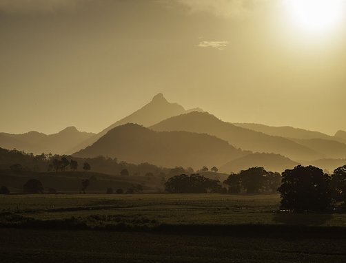
It all begins with Mt Warning, just the way it did around 23 million years ago. One of the best vantage points to get close enough to get a real feel and sense of its origin from a ground level perspective, is to follow Commercial Road down toward the boat ramp, where the road curves to the right and makes its way through the cane fields for about a kilometre. The road then changes to become a well maintained dirty gravel surface that takes you past more cane fields and rural properties, where you arrive at the end of the road. There, you’re presented with a panoramic view of the remnant Mt Warning shield volcano, JUST SPECTACULAR! If you can, make sure you plan this 5 minute drive out of town to coincide with a setting sun, where you’ll be rewarded with magnificent orange and red hues that paint the sky above Mt Warning in absolute delight. To give you a sneak peak, the photograph below, was taken from the very spot where the road changes from bitumen to dirt.
About a 30 minute drive from Murwillumbah, just over the border into Queensland, is one of the most unique pockets of wonder you could ever imagine. In my eyes, it’s not only sacred but also spectacular. It’s called Natural Arch and it’s located in Natural Bridge/Springbrook National Park.
I not only find it absolutely beautiful, but also challenging. What I mean by challenging is in terms of the available light when making photographs. I won’t give away too much, other than to say that when you arrive and stand in silence on the well catered-for walkways and raised platforms, to witness this wonder of nature, you’ll marvel at not only the amazing flow of water through the hole in the roof of the cave, but also at the intensity of the light that beams through, especially on a bright sunny day. There is so much to say about this location, so I’ll let my photographs give you a graphic understanding.
Only 30 minutes further down the road, through breathtaking roadside scenery, is a location that is very dear to my heart for a very special reason. It was the first photograph that I made and framed and then went onto sell as part of my life’s work. The location is the Best Of All Lookout that can be accessed when you make your way to the end of Repeater Station Road, high up on the plateau in Springbrook National Park. The jewels for me are a small stand of Antarctic Beach trees that you pass on the very accessible bitumen walkway that meanders through cool temperate rainforest, about 50 metres before you get to the lookout itself. Botanically known as Nothofagus moorei, these trees are growing remnants of an original seed and growth, dating approximately 2,000 years in existence. The added bonus at the end of the walkway, is the suspended viewing platform where Mt Warning and the surrounding Caldera can be viewed in all their glory from approximately 900 metres above the Caldera floor.
Every time I photograph these locations, I find myself click, click, clicking away, and then sitting quietly in reflection and awe.
Currumbin Rock Pools are located about a 30 minute drive from Murwillumbah and easily accessed via Tomewin Road, that leads you down into the Currumbin Valley, again through some wonderful roadside scenery with breathtaking escarpment vistas and views of The Saddle. Be sure to stop off at Freemans Organic Farm on Tomewin Mountain Road.
Amongst many of my favourite locations throughout the Tweed to photograph, Fingal Headland sits high on the list of significance, not only for unique beauty but also for its geological significance. It really has so much to explore, from the hexagonal shaped basalt columns that extend underwater to Cook Island, located just offshore and classified as a permanent aquatic marine reserve, to the pristine beaches either side of the headland. One more thing, the photograph that I took of the Osprey with its catch, was made down on Fingal Beach - a very memorable experience. For me, this is what a Tweed experience personifies… A Very Memorable Experience!

|
Mark Brombal photographs stills of travel, landscapes and nature and is based in Murwillumbah. A professional background in landscapes and trees has supported Mark to express his love of the natural world that has seen his photographic work exhibited, awarded and sold.
‘I’m passionate about the natural history of a landscape and how it has evolved into what we now see. The botanical history of the plant kingdom really draws my attention, together with the geology of a location and the natural elements and fauna that have evolved with it. I consider it a privilege to express my experiences of the natural world, through my photography’. |
Header image: Cave Creek, Springbrook National Park